Tropical Storm Milton Update 3

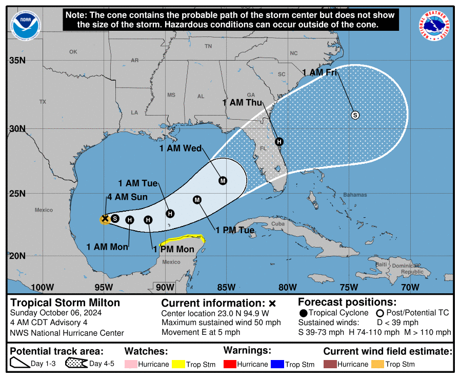
TS Milton Cone

TS Milton Wind Speeds


Current Location: 22.5N, 95.5W
Geographic Reference: 140 Miles East of Tampico, MX
Movement: Nearly Stationary
Max Winds: 45 mph gusting to 60 mph
Current Hurricane Severity Index: 3 out of a possible 50 points (1 size, 2 intensity)
Max Predicted Hurricane Severity Index: 21 out of a possible 50 points (9 size, 12 intensity)
Current Radius of Tropical Storm-Force Winds: 60 miles
Max Predicted Radius of Tropical Storm-Force Winds: 310 miles
Organizational Trend: Steadily Organizing
Forecast Confidence: Average
Estimated Central Pressure: 1005 mb
Key Points
- Tropical Storm Milton is forecasted to begin a slightly faster eastward to east-northeastward motion by Monday and into Tuesday.
- Tropical Storm Milton is forecast to remain over the southwestern Gulf of Mexico through Sunday night, then move across the south-central Gulf of Mexico on Monday and Tuesday and approach the west coast of Florida by midweek.
- Steady to rapid strengthening is forecast during the next few days, and Milton is expected to become a hurricane Sunday night.
- Tropical Storm Milton is predicted to become a major hurricane prior to reaching Florida on Wednesday. Winds are forecast to be 115 mph.
- Changes to the eventual track can be expected, it is important not to focus on single model runs or solutions!
- Significant wind and wave impacts are expected.
- Tropical storm-force conditions will most likely arrive along the West Florida coastline early Wednesday morning, and spreading eastward across the Florida Peninsula through the Wednesday daytime hours.
- There remains quite a bit of uncertainty regarding the forward speed and progression of Tropical Storm Milton.
Captiva Island Information
- A rain event is expected to push into the state this weekend, kicking off a wet and active weather pattern across the State of Florida, even prior to tropical impacts. Because of this, Flood Watches have been issued for the Florida Peninsula, spanning from the Nature Coast to along and south of the I-4 corridor beginning Sunday morning until Thursday morning.
- Rainfall amounts from the storm are expected to be 6-9 inches for Sanibel and Captiva Island on Wednesday.
- Possible storm surge of 5-10 feet are possible on Wednesday as the center nears the coast of Florida to the north. Major coastal flooding and some damage is expected.
- Travel is expected to be impacted!
- Any remaining sand from Hurricane Helene can be found here.
